Sun Mar 22, 2026 | Updated 11:20 AM IST HZ Awards 2026
The Chopta-Tungnath-Chandrashila Summit trek is one of the most beautiful Himalayan adventures you will experience, especially in April, when winter snow begins to melt, offering vibrant sunlight and the mountains' welcoming spring. Known for its breathtaking views of snow-capped peaks such as Nanda Devi and Trishul, it is often considered a rewarding trek for both beginners and experienced trekkers. However, April brings its own challenges, from slippery, steep peaks to cold early-morning treks. If you are planning a Chopta Chandrashila Tungnath trek during this time, it is essential to follow a clear step-by-step guide to reach the summit safely. Here's everything you need to know before you start your trip.
Chopta is a scenic hill station situated in the Rudraprayag district of Uttarakhand, India, in the Garhwal Himalayas at an altitude of approximately 2,680 meters. To get there, you need to reach Delhi first.
The journey starts from Delhi and takes around 10-14 hours by road, crossing Rishikesh, Devprayag, Srinagar, Rudraprayag, Ukhimath, and finally reaching Chopta.
Travellers usually take an overnight bus from Delhi to reach Rishikesh, book a rental scooter or shared taxi to reach Chopta by afternoon or evening, crossing the serene landscape of Alaknanda, Bhagirathi, Mandakini, and Ganges rivers.
Spend some time exploring Chopta, enjoying sunset views of the Chaukhamba mountain range, and take proper rest before starting the early morning trek.
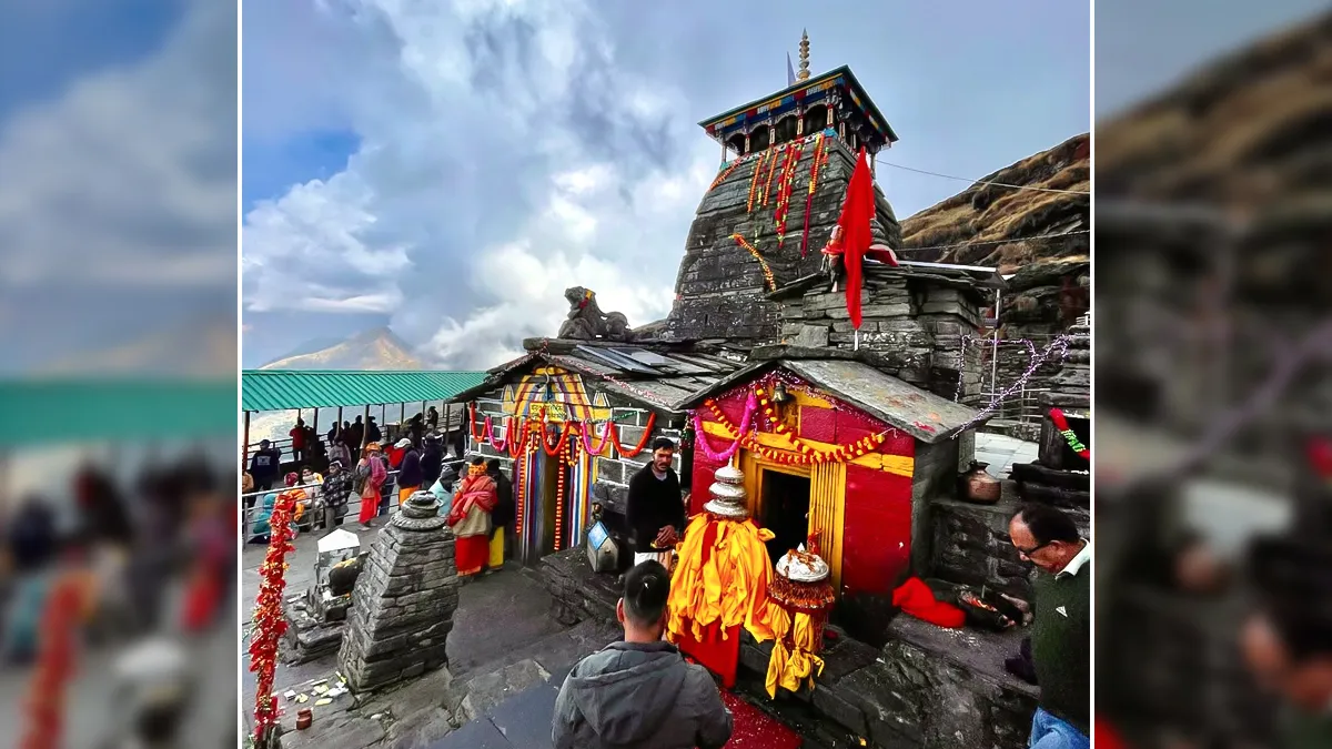
Start your trek early in the morning, around 3-4:00 am, to experience the divine sunrise from the summit. The total trekking distance is around 5 km one way, which passes through dense forests, now-capped steeps with spectacular views. The Tungnath temple is believed to be the highest Shiva temple in the world, a crucial part of the Panch Kedar, situated at 3,680 meters above sea level.
Chopta to Chandrashila Trek
Trek Segment |
Distance |
Estimated Time |
Terrain / Difficulty |
Chopta to Tungnath |
3.5 km |
2–3 Hours |
Paved path, moderate incline |
Tungnath to Chandrashila |
1.5 km |
1–2 Hours |
Steep climb, rocky terrain |
Total (One Way) |
5.0 km |
3–5 Hours |
Moderate |
ALSO READ- 5 Best Things To Do In Jim Corbett National Park For An Adventurous Vacation
After the surreal views from the Chandrashila summit and seeking blessings from the Tungnath temple, start your descent back to Chopta.
Chandrashila to Chopta Descent
Trek Segment |
Distance |
Estimated Time |
Terrain / Difficulty |
Chandrashila → Tungnath |
1.5 km |
45 min – 1 hour |
Steep descent, rocky |
Tungnath → Chopta |
3.5 km |
1.5 – 2 hours |
Gradual decline, paved |
Total Descent |
5.0 km |
2.25 – 3 hours |
Easy to Moderate |
Note: The time for trekking uphill and downhill depends on your pace and the snow and weather conditions.
You can relax after reaching Chopta and drive back to Rishikesh, which takes around six to seven hours from Chopta, crossing Ukhimath, Rudraparyag, Srinagar, and Devparayag.
ALSO READ- Discover Ujjain: 5 Must-Visit Places For A Divine And Unforgettable Trip
Upon reaching Rishikesh, you can spend the night exploring the city and taking some rest, or you can get overnight bus services to Delhi.
Start your trek early in the morning to witness the breathtaking sunrise from Chandrashila Peak.
Wear proper trekking shoes as the route may have snow patches and slippery, steep slopes.
Carry warm layers as temperatures still drop to zero degrees Celsius at higher altitudes.
Stay hydrated and carry enough snacks, as there are limited food stalls along the route.
Check the weather and snow conditions before starting your trek.
For more such stories, please follow HerZindagi!
Image Credit: Instagram, Freepik
Also watch this video
Herzindagi video
Our aim is to provide accurate, safe and expert verified information through our articles and social media handles. The remedies, advice and tips mentioned here are for general information only. Please consult your expert before trying any kind of health, beauty, life hacks or astrology related tips. For any feedback or complaint, contact us at [email protected].